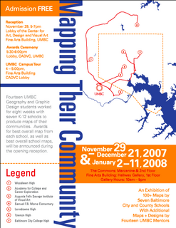
An Exhibition of
100+ Maps by
Seven Baltimore City and County Schools
With Additional Maps + Designs by Fourteen UMBC Mentors
November 29 – December 21, 2007 / January 2 – 11, 2008
The Commons & Fine Arts Building, Hallway Gallery, 1st floor
Exhibition Hours: 10am – 5pm, Monday – Saturday
Carefully researched and designed maps educate the public and cause social awareness. Fourteen UMBC Geography and Graphic Design students worked for eight weeks with seven K-12 schools to produce maps of their communities. Awards for best overall map from each school as well as best overall school maps will be announced during the opening reception. Organized by the Center for Art, Design and Visual Culture, UMBC, in partnership with Assistant Professor Guenet Abraham, Visual Arts Department and the Department of Geography, UMBC, and the Walters Art Museum’s Department of Education in cooperation with and the Shriver Center.
Reception
Thursday, November 29, 5-7:00 p.m. / Lobby of the Center for Art, Design and Visual Art / Fine Arts Building, UMBC
Awards Ceremony / 5:30-6:00 p.m. / Lobby, CADVC, UMBC / UMBC Campus Tour 4 – 5:00 p.m., Fine Arts Building, CADVC Lobby


